
Take to the skies and climb the 15 peaks in the Kaysersberg valley, 9 of which are over 1000m high. Some offer unobstructed views, sometimes even 360°, so you can appreciate the full beauty of the landscape. Others, more discreet, are well worth the diversions for their geological and historical curiosity, and their magical and rejuvenating setting. Come up and discover these renowned spots that make up the valley’s rich natural heritage.
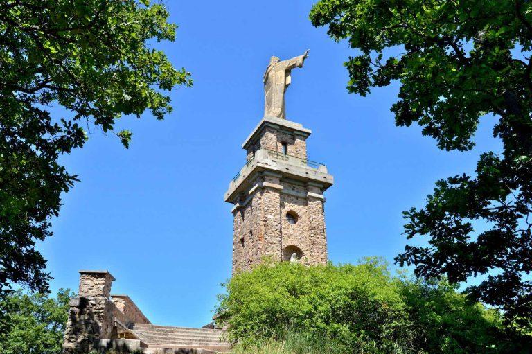
The Galtz (732m)
Although it is only slightly higher than some of the other mountains in the valley, it is a must-see in the region. Arriving from the Alsace Wine Route, it’s easy to recognise Galtz mountain by the silhouette of the large statue of Christ at its summit. Situated between the villages of Ammerschwihr, Katzenthal and Niedermorschwihr, there are numerous starting points and hiking trails to reach it. At the top is the Galtz monument, also known as the “Alsatian Corcovado”, dedicated to the memory of the victims of the First World War. The total height of the monument is 23 metres, including 7.5 metres for Christ. You can climb up to the platform of the pedestal to enjoy a sensational 360° view. It’s an unmissable spot from which to take in the majestic expanse of the vineyards or immortalise the flamboyant autumn colours.

The Faudé (773m)
Le Faudé is a small massif between Orbey and Lapoutroie that is hard to miss. Just as the sea has its lighthouse, the Pays Welche has its tower. A veritable lookout point, it is easy to spot from near and far as soon as you reach the mountainous side of the valley. The forest that shelters it is mainly made up of tall pine trees, providing a welcome source of coolness in summer. Easily accessible, it is used by sports enthusiasts for a variety of activities: hiking, mountain biking, horse riding, running, etc. all year round. The tower at the top can be reached either via the main path, which climbs in a spiral, or by taking the traverses, which are quicker both in terms of time and gradient. From there, there are still 92 steps to climb to enjoy the breathtaking panorama.

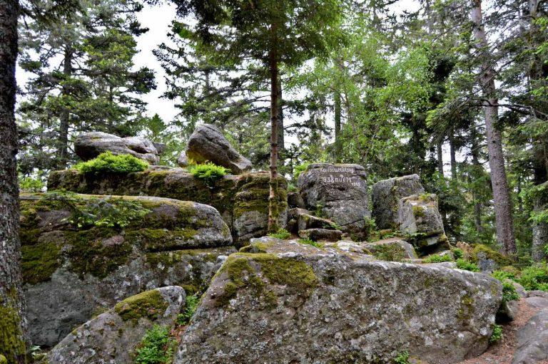
The Rain des Chênes (884m)
Le Rain des Chênes is an enchanting place with its trembling rocks. In a magnificent pine forest bordered by a wild blueberry heath, you will discover two enormous tabular rocks. They have been detached by erosion from the sandstone that forms the crest of the Rain des Chênes. 200 million years old, this is a sedimentary rock composed of a mixture of sand and pebbles, the aggregation of which can easily be seen on the base of the stones. It was once used as a place of worship, but above all as a judgement stone. Legend has it that if the accused could move the stone, his innocence would be proven. To do so, he had to find the precise spot that allowed the stone to wobble. On the same principle, when a husband wanted to check his wife’s fidelity, he had to stand under the stone and touch it with his index finger. If the stone moved, the wife was faithful. In the forest, there are many remains of trenches and shell holes. Situated not far from the Linge, where the French and Germans clashed from February to October 1915, this summit also bears witness to the bloody fighting.
The Koenigsstuhl (945m)
The Koenigsstuhl holds a place among the unsuspected peaks that are rarely reached by chance, but are nevertheless well worth seeing. The path winds through a magnificent pine forest, the verticality of which contrasts with the rectilinear trajectory of the path, bordered on either side by curiously shaped rocks, indicative of Celtic occupation. Once you’ve reached the summit, you’ll discover a picturesque and enchanting site hidden away in the middle of the woods, formed by boulders. In this unusual setting, the name of the summit takes on its full meaning, because from its literal translation “King’s chair”, there is actually a stone hollowed out in the shape of a seat bearing the engraved inscription “Koenigsthul”. In the same spirit, the Roche du Tétras, just a fifteen-minute walk away, features a magnificent circus of stones. Stacked vertically and horizontally and sculpted by erosion and human action, the site triggers the “wow” effect.
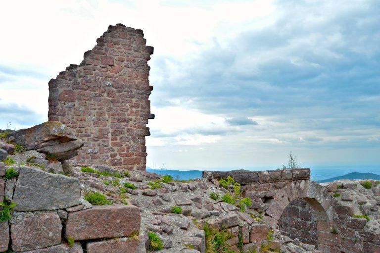
The Petit Hohnack (927m)
The Petit Hohnack is located in the commune of Labaroche and what makes it exceptional are the remains of the castle that it shelters. At first glance, it is a very pleasant massif to walk around, as it is mainly covered in pine trees. When you see it in the distance, you notice that it has a bald head, but you’d never suspect that it contains this treasure from the past. It dates back to the end of the 11th century and was built by the Counts of Eguisheim, before becoming the property of the Ribeaupierre family. Louis XIV had it demolished in the 17th century, as it no longer served the strategic purpose for which it was intended. Today, it is considered to be the highest castle in Alsace in terms of altitude, from where you can enjoy a beautiful view over the plain and the surrounding area. There is also a fun walk for children to take them to the top.
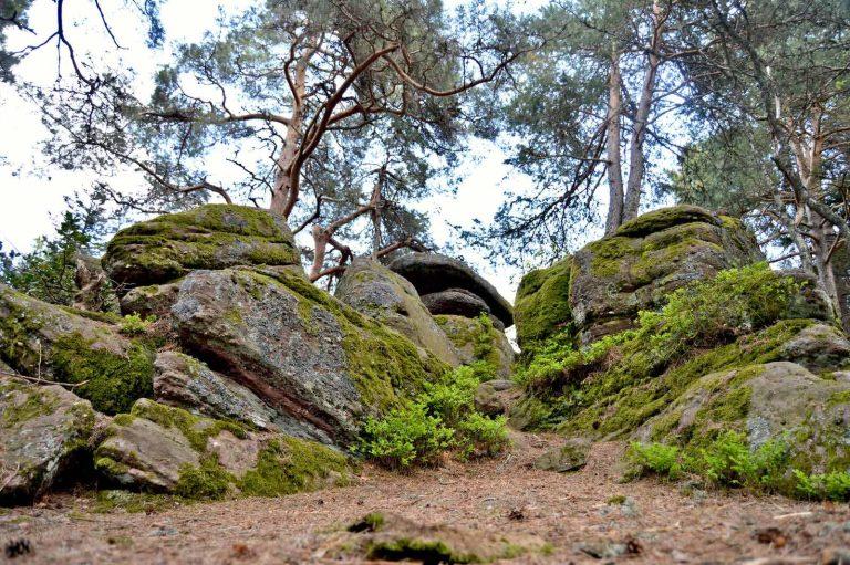
The Grand Hohnack (982m)
The Grand Hohnack is not to be confused with the Hohneck, the third highest peak in the Vosges massif. However, the Hohnack is well worth a visit. The little path leading up to it winds through wild blueberries and pine trees, creating a fairytale setting. It’s all the more striking when you discover the surprisingly shaped rocky mass at the summit. Over time, nature shapes the elements to create veritable works of art. It is said that this labyrinth of stones is the tomb of a giant who was responsible for the creation of the Vosges. If you listen carefully, it’s rumoured that you can still hear his roar from time to time. Let your childlike spirit explore the area by climbing these sandstone rocks and you’ll discover the famous “fairy vat” among them. This rock is distinguished by its hollowed-out cavities: a geological gem or a human creation used as a place of worship? their formation remains a mystery.
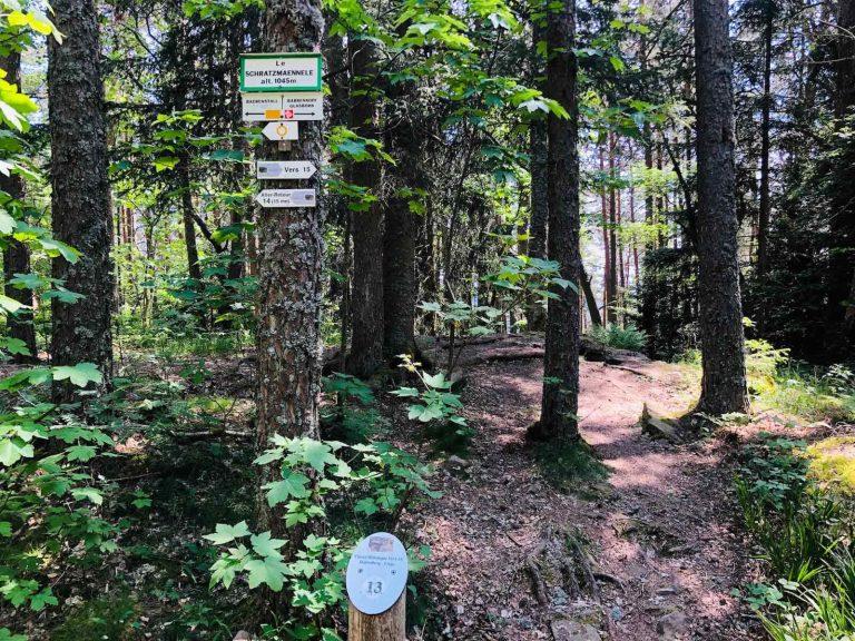
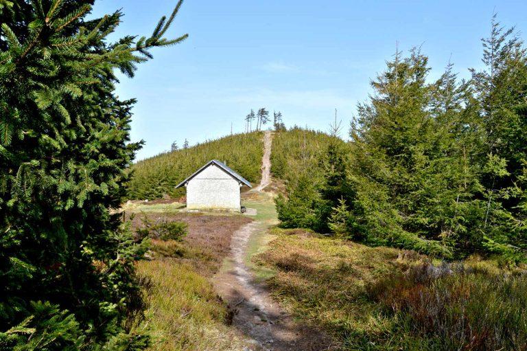
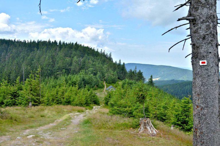
The Schratzmaennele (1045m)
The Schratzmaennele lies between the communes of Orbey and Hohrod in the Munster valley. The Collet du Linge, at an altitude of 987m, is more commonly associated with the particularly deadly fighting that took place between July and October 1915. The Schratzmaennele is quite simply the highest point of the German army’s first line of attack. The path to reach it is dotted with numerous relics of war. To find out more about the history of these places, the Linge Memorial Museum, just a few metres away, provides a detailed account of the terrible events. It’s a place like no other, with immersive installations that invite you to step back in time.

The Tête des chats (1080m)
The Tête des Chats is located in the immediate vicinity of the Col des Bagenelles, which is better known but not as high (905m). This summit lies at the crossroads of three areas: La Croix-aux-Mines, Le Bonhomme and Sainte-Marie-aux-Mines, forming a natural boundary between the Vosges and Haut-Rhin departments. Accessible on foot, it is one of the peaks that border the Route des Crêtes to the north, from where you can see the Grand Brézouard. In winter, it is the highest point in the small ski resort of Les Bagenelles. The “Graine-Johé” ski lift serves 3 downhill ski runs that descend to the foot of the eponymous inn. An off-the-beaten-track summit that, in summer and winter alike, actively disconnects you at an altitude of over 1000m.
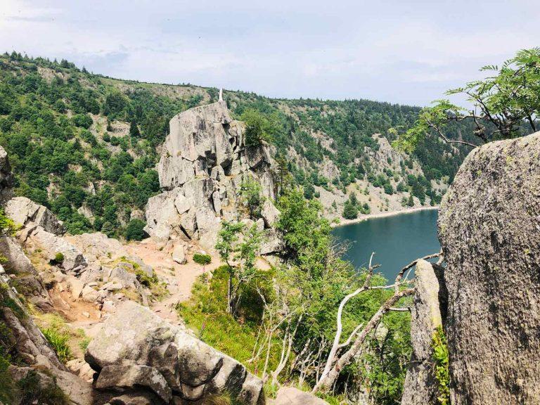
The rocher Hans (1144m)
This is a summit that will test your endurance to the limit if you choose to reach it via the rock face from the Lac Blanc car park. It is easily identified by the statue of the Virgin Mary that dominates it. It can be reached by climbing, but on foot you’ll find yourself on the rocky platform above. At the top, the magic is instantaneous and will leave you speechless. Within its natural enclosure of sheer cliffs reflecting a glacial depression and fir trees, the lake shines. Many stories are told about this place. The best known is the legend of Hans Castle by Maurice Pottecher, which was once a huge success when it was performed at the Théâtre du Peuple in Bussang. The story goes that a woodcutter called Hans lived in a hut at the foot of the rock. A young girl from the area falls in love with him. Under the influence of the devil, Hans gave up on this beautiful love story and lived unhappily for several years. But fate finally reunited them. They build a castle on the rock to live out their love in the open. The devil, jealous, pushes them into the lake to destroy them. The story has a happy ending, as the couple emerge from the lake to live happily ever after in the woodcutter’s old hut. Others say that it was the fairies who pushed the castle into the water to protect the young girl, and that today only the pure of heart can see the reflection of the castle where the couple live happily ever after.
The Tête des Faux (1208m)
The Tête des Faux is a summit in its own right and well worth the climb. Although it is one of the highest peaks in the valley, don’t expect an unobstructed view, but a much more cultural discovery. The mountain was considered a strategic site during the First World War, with the front line passing directly over its summit. The battlefield is still visible today, with numerous remains (forts, barbed wire, trenches) along the way. Below to the west is the French military cemetery “Cimetière Duchesne”, a UNESCO World Heritage Site. To the east, unspoilt countryside dominates, with the Etang du Devin, a natural peat bog listed as a Natura 2000 site.
The Tête des Immerlins (1216m) and the Petite Tête des Immerlins (1143m)
The Tête des Immerlins and Petite Tête des Immerlins follow one another just a few kilometres apart.
Recently, the path leading to the Tête des Immerlins has been diverted: it now bypasses the summit to preserve this sanctuary, which is home to several Western Capercaillies being reintroduced to the area.
Starting from the Duchesne cemetery, you can take this path to reach the Petite Tête des Immerlins and climb to its summit. Although little known, this summit is just as easily accessible from the Col du Calvaire, making it perfect for a short family walk. In winter, it can be reached with snowshoes. The summit of the Petite Tête des Immerlins, which is more bare than its neighbour, offers a distant view of the natural cirque of Lac Blanc, formed by a glacial depression. Although the water of the lake is not directly visible, the natural amphitheatre surrounded by steep walls is clearly identifiable.
The Petit Brézouard (1203m)
Petit Brézouard is best known to GR5 walkers for the refuge at its foot. The hut is unguarded but well-equipped to provide a night’s rest for long-distance walkers. From the hut, the summit can be seen with the naked eye like nowhere else. You can clearly see a hill, the left side of which slopes down towards the valley of Sainte-Marie-aux-Mines, while the right slopes down towards Fréland. At the summit, the few remaining large fir trees give the ironic image of a bald skull, but above all they reflect the damage caused by the storm of December 1999. The path to the top is as straight as the Avenue des Champs-Elysées, but steeper, offering a lovely panoramic view of the Vosges mountains on one side and the expanse of the Alsace plain on the other.
The Grand Brézouard (1229m)
Grand Brézouard is a little-known peak, despite being the second highest in the region. It lies at the crossroads of the Kaysersberg (between Lapoutroie and Fréland) and Sainte-Marie-aux-Mines valleys. With its altitude of over 1,200m, it’s not unusual for it to have its head in the clouds on foggy days, or to be one of the first to welcome the white gold at the start of winter. Much of the mountain range is made up of forests, which in the past were heavily damaged by fire and shellfire. Today, its great tranquillity makes it an area that is favourable to the preservation of species.
It is for this reason that access to the summit has recently been banned in order to preserve the remaining capercaillie population. You can still enjoy the massif, which is crossed by the emblematic GR5.
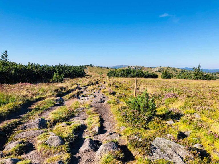
Gazon du Faing (1306m)
The Gazon du Faing is THE summit of the valley par excellence. Although on the surface the summit is almost flat due to the wide open expanse of the high thatch (high altitude meadows) that make up the protected reserve, below it are very steep cliffs where the Lac des Truites, the highest lake in the Vosges massif, is nestled. This summit is considered to be the most beautiful because it contains all the typical landscapes of the Vosges ridges. You’ll find the emblematic chamois, a diverse flora and, above all, a breathtaking view over the surrounding valleys as far as the Alsace plain. If the conditions are right, you’ll be able to see the peaks of the Bernese Alps. It is said that when they appear, a change in the weather is to be expected.