
All the hiking trails that criss-cross the valley are based on the Club Vosgien signposting. This association of volunteers, created in 1872, works to maintain and mark out the hiking trails of the Vosges massif. Thanks to their hard work, we are able to guide you simply and serenely along the valley’s paths.
Before setting off on your hike, here is some useful information to help you understand how the markings work, because it is not by chance that the coloured geometric shapes are used:
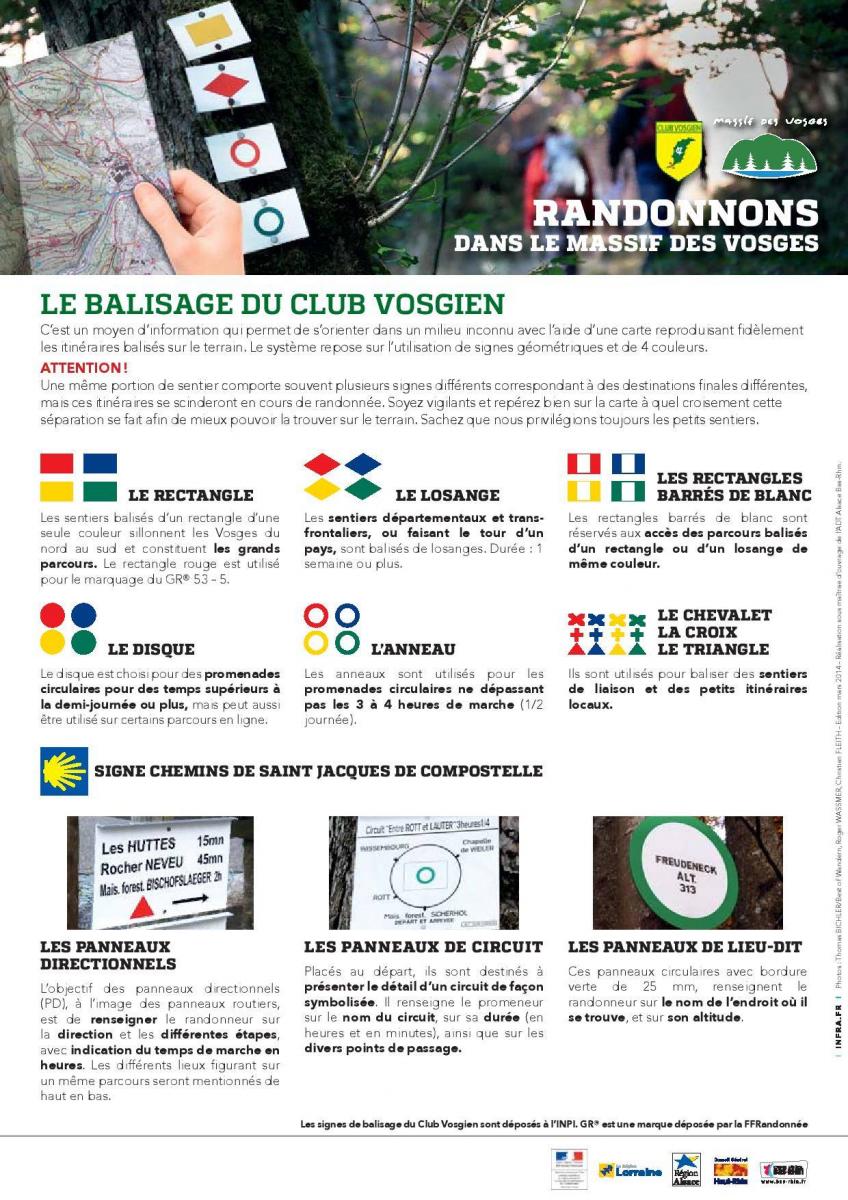
- the long-distance paths (GR) are always marked by rectangles, such as the GR5, the GR532 and the GR531 which cross the Kaysersberg valley.
- inter-departmental paths are marked with diamonds,
- circular routes are marked by discs or rings,
- the small hikes are marked by triangles, crosses or easels.
To make a loop, do not follow the same symbol from one end to the other, as this could lead to a very long one-way trip. The use of several symbols is necessary, which is why we provide you with the right tools (available on line or in our reception offices) to set off in total autonomy and serenity on the valley’s paths.

The topographic map (IGN) remains the most accurate tool for finding your way around. No need to have a network, it is a safe bet to carry in your rucksack, especially if you plan to go on a long hike. Reading it can be complex if you have fun unravelling all the elements that make it up. Rest assured, you can get by without being an expert map reader.
Preferably, choose a map with a scale of 1:25000 (1cm = 250m). Its accuracy will allow you to spot all the natural elements down to the smallest paths to find your way around easily.
Start by orienting your map in the right direction. To do this, forget about North, moss and the stars. Instead, start with an easily identifiable feature (building, river, village) and turn your map so that it matches the terrain. Remember, your map is an image of the place, like a photograph.
In order to finally move forward in the right direction, let’s move on to the actual reading of the map. The more experienced will know how to deconstruct it more or less precisely by identifying the relief with the contour lines, the equidistance to estimate the distance between two points, the recognition of the type of terrain according to the colorimetry used, etc… Deepening this knowledge will be very useful if you wish to compose your own hike. This will allow you to judge the difficulty, distance and time needed to complete the route you have in mind.
By basing yourself on a route that has already been designed (known path, markings and practical information), reading an IGN map will be easier and more accessible. And then you say to yourself: why take an IGN map if you already have a toporando? Very good question! It is not compulsory to take it with you if you already have a pre-designed and detailed circuit. We recommend it if you wish to increase your serenity. It will be your ally in confirming your choice to be or to take the right path in case of doubt. The advantage is that this primary use requires little knowledge. In practice, the hiking trails are marked with red lines and the geometric symbols on the trees are shown on the map. All you have to do is find your way around the map and identify the intersection where you need to change the markings. This is a good start for the first time.
Now that you know how and why to use an IGN map, you’re ready to hit the trails of the valley with confidence.